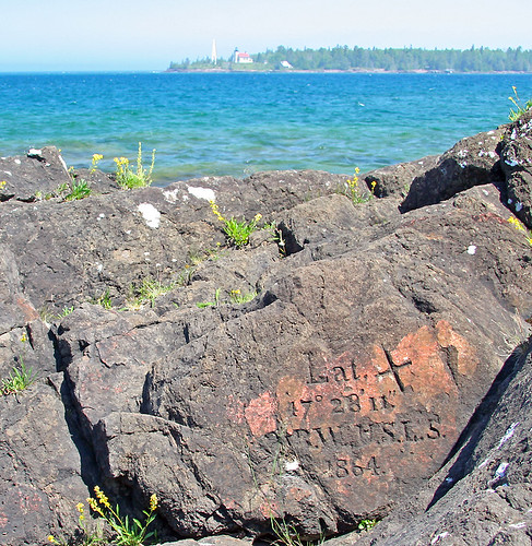
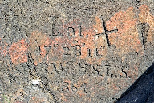
 Couple of year ago, when walking near Copper Harbor (Upper Michigan), I found this survey sign from 1864.
Last week I've received email form another Flickr user about this sign:
"Just returned from CH [Copper Harbor], and after much hunting found the rock! I have been on edge waiting to get back up there after seeing your photo AFTER our return from a prior trip. I see that you noted that it was a survey mark from 1864, do you have any more information on the markings? I assumed it was the United States Lighthouse Service, but the mark pre-dates them. If you have any info please shoot me an email."
Nice when your photo inspired someone :-)
My answer:
"I don't know purpose of this sign for sure (and people in the Fort Wilkins didn't know either :-) ), however I think, there are two possibilities.
Version #1:
First light tower has been built in 1848. Current lighthouse building has been built in 1866, current light tower has been built in 1930s.
So, I think you are right: survey is related to the construction of lighthouse - just two years difference (1864 - 1866).
Version #2:
It's not possible to get to the CH port directly from the lake - too many underwater rocks. Boats (even now) have to go close to the shore in the area of lighthouse, and after this go along the shore to the port.
When you are looking at the survey sign, there is navigation sign (large white board) behind your back. Survey could be related to this navigation sign.
Actually, I think that both versions could be right same time: survey done by United States Lighthouse Service to build navigational infrastructure there.
I didn't know about survey, I walked around taking photos, and it was very nice surprise when I've noticed this sign.
Copper Harbor and around is amazing place. I've been there once, and I definitely will visit this place again."